How to mitigate the ionospheric influence on GNSS positioning?
Wenfeng Zhang, Tersus GNSS 8 Sept. 2023
1. What is the ionosphere?
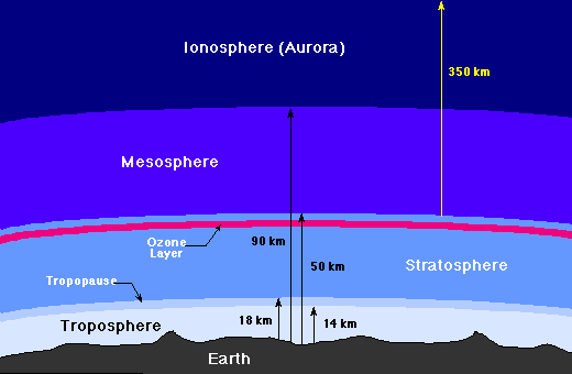
The ionosphere resides within Earth's upper atmosphere, spanning an altitude range of approximately 50 to 600 kilometers above the Earth's surface. Alongside the neutral upper atmosphere, it serves as the interface between the terrestrial lower atmosphere, where human activities occur, and the vast expanse of outer space. This dynamic region, known as the ionosphere, is in a constant state of flux. Its ever-changing nature is a result of influences originating from both the Earth's surface and the space environment, making it a challenge to precisely predict its characteristics at any given moment. The ionosphere plays a pivotal role in various aspects of our daily lives, particularly in communication and navigation systems. Signals for radio communication and GPS navigation traverse through this atmospheric layer, utilizing its unique properties to reach their intended destinations. These signals either pass through the ionosphere or utilize its reflective properties to facilitate their journey. However, the ionosphere's composition and density are subject to fluctuations, and these variations can interfere with the transmission and reception of these signals.

2. What impact does the ionosphere has on GNSS positioning?
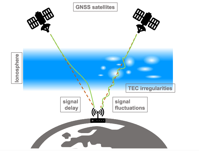
One of the largest errors in GNSS (Global Navigation Satellite System) measurements can be attributed to ionospheric delay, where the presence of free electrons in the ionosphere affects the transmission of GNSS signals. The impact on GNSS systems is primarily determined by the carrier frequency and the concentration of Total Electron Content (TEC). Ionospheric delay introduces errors in distance measurements, which can reach up to 15 meters during the daytime and 3 meters at night. The vertical direction can experience delays of up to 50 meters, while the horizontal direction can reach up to 150 meters. In relative positioning, strong ionospheric correlations can largely mitigate delay effects for short baselines. However, longer baselines leave significant residuals from ionospheric delay, making accurate integer ambiguity resolution challenging.
The ionospheric influence on RTK (Real-Time Kinematic) positioning manifests in the following ways:
1)During periods of intense ionospheric activity, double-difference ambiguities increase, making the resolution of integer ambiguities more difficult and prolonging the time required for fixing solutions.
2)When ionospheric or geomagnetic anomalies are present, there exists a certain level of discrepancy between estimated and computed atmospheric corrections. Previous studies have shown that residuals from higher-order ionospheric terms exceeding 8 centimeters significantly affect ambiguity resolution and coordinate estimation.

3. How to mitigate the ionospheric influence on GNSS positioning
1)Surveyors should conduct observations at more suitable times, avoiding unfavorable conditions such as solar flares and intense solar radiation, especially during high-precision measurements. Generally, stronger sunlight leads to more active ionospheric behavior. As a result, ionospheric activity typically peaks around 2 PM, making it advisable for surveyors to avoid work during midday.
2) It's recommended to perform short baseline measurements when ionospheric effects are active to ensure reliable positioning results. Real-Time Kinematic (RTK) positioning relies on corrections from reference stations to eliminate common errors in the moving station. If there's a significant ionospheric discrepancy between two stations, ionospheric errors cannot be effectively eliminated.
3) If changing the baseline to a short one isn't feasible, surveyors can opt to conduct measurements at night with longer baselines. In such cases, scheduling observations at two different time periods is recommended to achieve greater reliability in accuracy.
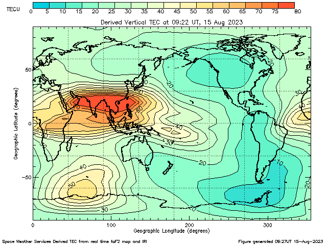
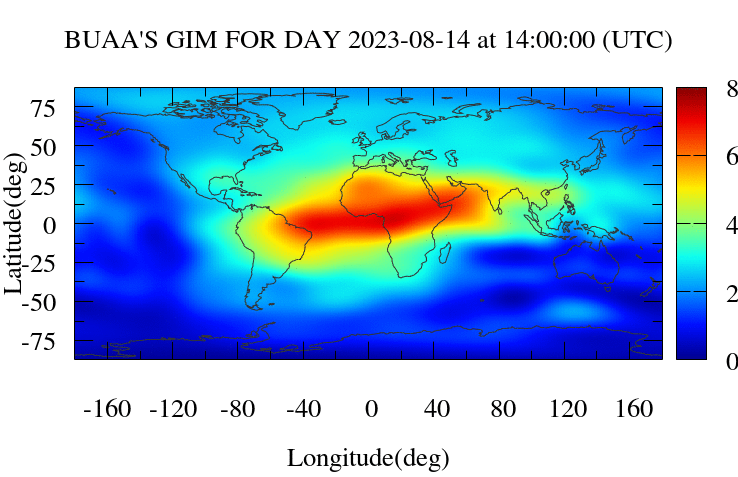
4) Utilize real-time ionospheric monitoring through global ionospheric websites. Avoid conducting measurements during active ionospheric conditions. Websites like https://www.sws.bom.gov.au/Satellite/2/2 and http://ionosphere.cn/ provide valuable information on ionospheric status.


About Tersus GNSS Inc.
Tersus GNSS is a leading Global Navigation Satellite System (GNSS) solution provider. Our offerings and services aim to make centimeter-precision positioning affordable for large-scale deployment.
Founded in 2014, we have been pioneers in design and development GNSS RTK products to better cater to the industry’s needs. Our portfolios cover GNSS RTK & PPK OEM boards, David GNSS Receiver, Oscar GNSS Receiver, MatrixRTK [GNSS CORS Systems] and inertial navigation systems.
Designed for ease of use, our solutions support multi-GNSS and provide flexible interfaces for a variety of applications, such as UAVs, surveying, mapping, precision agriculture, lane-level navigation, construction engineering, and deformation monitoring.
Sales inquiry: sales@tersus-gnss.com
Technical support: support@tersus-gnss.com
