What is Satellite Orientation in GNSS?
Mila Tao, Tersus GNSS 28 Jun. 2024
What is Satellite Orientation in GNSS?
The development of Global Navigation Satellite Systems (GNSS) has made satellite orientation technology a critical component in modern navigation. This article will explore the definition, principles, methods for enhancing orientation accuracy, and applications of satellite orientation technology.
Definition
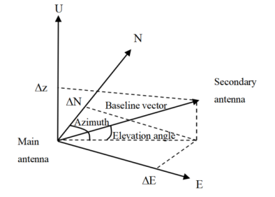
Satellite orientation technology refers to the method of determining the orientation or attitude of a carrier by receiving and processing signals from satellite systems such as GPS, GLONASS, Galileo, and BeiDou. It is based on the principle of satellite carrier phase signal interferometry, which allows for the determination of the direction of a geometric vector formed between two points in space in a given coordinate system.

Note: The two points in space generally refer to the physical phase centers of two measurement antennas. The coordinate system can be the Earth-Centered, Earth-Fixed (ECEF) coordinate system, local horizontal coordinate systems, and others. The local horizontal coordinate system is commonly used, where the baseline vector can be directly used to compute the azimuth relative to true north and the elevation angle relative to the horizontal plane.
Compared to traditional orientation methods
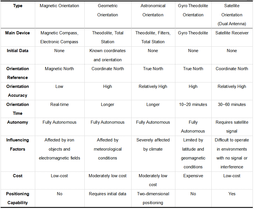
Different orientation methods have their own characteristics and application scopes. Here is a comparison between GNSS orientation technology and traditional directional measurement techniques, refer to the following figure:

It is evident that compared to traditional orientation methods, GNSS orientation offers the following advantages:
1. High precision: It can achieve high-precision orientation of target locations, meeting the positioning requirements of various application scenarios.
2. Real-time: It can obtain directional information of target positions in real-time, suitable for scenarios requiring real-time monitoring and navigation.
3. Interference resistance: By utilizing multipath effects, it can reduce the impact of signal interference, enhancing the accuracy and stability of measurements.
4. Low cost: The device used is relatively simple and low-cost, making it suitable for widespread use.
GNSS dual-antenna orientation
GNSS dual-antenna orientation technology is a method that utilizes two GNSS receiver antennas for positioning and attitude measurement. It is widely applied in fields such as ground vehicles, ships, and unmanned aerial vehicles (UAVs), used for accurately determining an object's location, direction, and attitude (such as pitch, roll, and yaw). This technology provides more precise and reliable measurement results compared to those obtained with a single GNSS antenna.
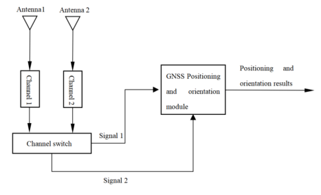
Dual-Antenna Orientation System:

To achieve orientation, the key is to solve for the baseline vector. The measurement process mainly includes the following steps:
1. Signal reception: The two GNSS antennas each receive signals from multiple GNSS satellites.
2. Differential correction: Using differential techniques (such as RTK), the received signals are corrected, significantly improving measurement accuracy.
3. Baseline calculation: Based on the differences in signals received by the two antennas, the relative position between the two antennas is calculated, which is the baseline vector.
4. Attitude solution: Based on the relationship between the baseline vector and a known Earth reference coordinate system, the attitude angles of the platform are determined.
How to improve orientation accuracy
1. Use high-quality GNSS receivers and antennas: Choosing high-performance GNSS receivers and antennas is crucial for improving measurement accuracy. High-quality device can more effectively reduce noise, providing more stable and accurate signal reception.
2. Optimize antenna layout: Properly arranging dual antennas can significantly impact the accuracy of orientation results. Antenna layout should be optimized based on specific applications and environmental conditions.
3. Multi-frequency and multi-system integration: Using multi-frequency GNSS data (e.g., L1, L2, L5 signals) and integrating multiple constellations (e.g., GPS, GLONASS, Galileo, BeiDou) can significantly improve orientation accuracy. Multi-frequency data helps correct ionospheric delay, while multi-system data increases the number of available satellites, enhancing reliability and stability.
4. Eliminate multi-path effects: Reflected GNSS signals are a major factor affecting GNSS orientation accuracy. Selecting open areas for measurements, avoiding nearby reflective objects (like buildings and trees), and using antennas and receivers that can reduce multi-path effects are effective ways to improve accuracy.
5. Integrate assisted orientation technologies: Combining other sensors, such as Inertial Navigation Systems (INS) and ground-based stations, can improve the robustness and accuracy of orientation systems.
Applications
1. GNSS compass, real-time indication of north direction information: This has high accuracy, is not affected by geomagnetic fields and local environments, is low-cost, and can still provide direction information near polar regions.
2. Assisted INS rapid initial alignment: GNSS rapid orientation provides true north azimuth information to INS, allowing for quick and high-precision initial alignment, enhancing INS response capabilities.
3. Deformation monitoring: By continuously observing the vector between two spatial points, orientation technology can accurately determine the relative 3D motion at both ends of the vector. This is widely used to monitor tectonic movements, sea and river level changes, local crustal deformation, deformation of structures, mining-induced ground subsidence, and offshore oil exploration platform subsidence.
4. Satellite/INS combined heading determination: Integrating satellite orientation into a satellite/INS combination provides real-time heading information, applicable to a wide range of fields such as drones, unmanned reconnaissance vehicles, ships, and cruise planes.
About Tersus GNSS Inc.
Tersus GNSS is a leading Global Navigation Satellite System (GNSS) solution provider. Our offerings and services aim to make centimeter-precision positioning affordable for large-scale deployment.
Founded in 2014, we have been pioneers in design and development GNSS RTK products to better cater to the industry’s needs. Our portfolios cover GNSS RTK & PPK OEM boards, David GNSS Receiver, Oscar GNSS Receiver, MatrixRTK [GNSS CORS Systems] and inertial navigation systems.
Designed for ease of use, our solutions support multi-GNSS and provide flexible interfaces for a variety of applications, such as UAVs, surveying, mapping, precision agriculture, lane-level navigation, construction engineering, and deformation monitoring.
Sales inquiry: sales@tersus-gnss.com
Technical support: support@tersus-gnss.com
