Key Technical Parameters of Laser Surveying and Mapping
Lance Dong, Tersus GNSS 16 Dec. 2024
LiDAR scanning is a technology that uses laser technology for high-precision ranging and modeling imaging. Its relatively complex professional terms and some technical parameters often confuse entry-level users. This article will analyze the important technical parameters one by one.
1. Ranging Accuracy
Refers to the accuracy of laser radar in measuring the distance of the target, usually in centimeters or millimeters. High-precision laser radar (such as ±1-2 cm ranging accuracy) is suitable for engineering surveying and terrain modeling. The laser radar integrated and used by MVP can achieve a ranging accuracy of 1cm, which is also one of the basic guarantees for point cloud accuracy.
There are many factors that affect ranging accuracy. The reflection characteristics of lasers of different wavelengths on different materials may affect ranging accuracy; atmospheric conditions (such as rain, fog, snow) and changes in light will affect the propagation and reflection of laser signals, thereby affecting ranging accuracy; the color, material and shape of the target object will affect the reflectivity of the laser, which in turn affects the measurement results; generally speaking, ranging accuracy will decrease with the increase of the measurement distance.
2. Scan Range
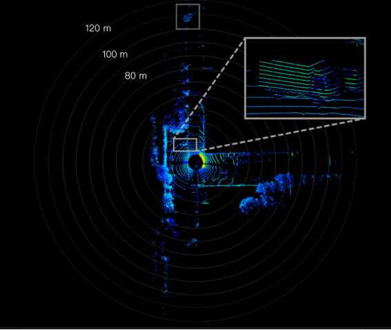
The maximum and minimum distances that laser radar can effectively measure. Different types of LiDAR may have ranging ranges from a few meters to several kilometers, suitable for different application scenarios.
Generally speaking, the higher the laser emission power, the stronger the ranging capability and the longer the ranging, which is suitable for large-scale terrain mapping and aerial laser scanning.
There are differences between the lasers of MVP-XT32 and MVP-M2X, so their scan rang is also different, 120m and 300m respectively.

3. Return
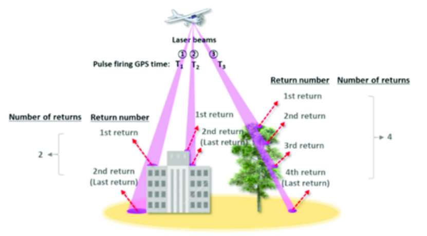
The number of point cloud return refers to the number of reflected laser signals received by the lidar system after a laser pulse is emitted. If a laser pulse is reflected by multiple targets (such as tree crowns, ground, etc.) after passing through leaves, multiple returns may be received. LiDAR echoes can generally be divided into the following types:
Single return: Only one reflected signal is returned, usually used to measure flat or single object surfaces. Dual return: Two reflected signals are returned, commonly seen in trees or other vegetation, the first return may come from the tree crown, and the second return comes from the under-tree ground. Multi-return: Multiple signals are returned, suitable for complex scenes, such as dense forests, and can capture different levels of information.

4. Max. Effective Measurement Rate
The number of laser points that a LiDAR can generate per second, usually expressed in points per second (pts/s).
The higher the point frequency, the more data points are obtained per unit time, and dynamic or complex scenes can be captured more finely. In autonomous driving and drone mapping, high-frequency scanning helps real-time environmental perception; in complex or dynamic environments, such as urban building mapping, higher point frequencies can capture more details.
Each return of MVP can reach a high frequency of 640,000 pts/s, thereby obtaining detailed and rich target information. MVP-XT32 measures 1,280,000 pts/s in dual return mode, MVP-M2X measures 1,920,000 pts/s in triple return mode.
5. Field of view (FOV)
The angular range that a lidar sensor can scan, usually expressed in degrees (°).
The larger the field of view, the wider the area covered, but it may affect the resolution and accuracy of the data. In urban planning and building inspections, a larger field of view can capture building information more comprehensively and improve work efficiency.
6. Laser wavelength
The wavelength of the laser light wave used by lidar is usually in the near-infrared band. Lasers of different wavelengths have different penetration capabilities on different materials. The 1550nm wavelength has stronger penetration capabilities for vegetation and is suitable for forest resource monitoring and ground measurement; in some dry or highly reflective environments, there may be problems with weak reflection signals. The 905nm wavelength performs well on many surfaces; it may not perform as well as 1550nm in areas with heavy vegetation or in complex environmental conditions (such as rain and fog).
Currently, mechanical rotating laser radars with a field of view of 360° on the market mostly use 905nm wavelength lasers, while single-line scanning laser radars with limited field of view mostly use 1550nm wavelength lasers.
7. Reflectivity
Reflectivity refers to the ratio of the laser energy reflected back to the laser radar after the laser beam hits the target surface to the irradiation energy, usually expressed as a percentage.
The smoothness, color and texture of the surface will affect the reflectivity. Smooth surfaces usually have higher reflectivity, while rough or porous surfaces may have lower reflectivity. Different materials (such as metals, plastics, soil, vegetation, etc.) have different reflectivities to lasers. For example, metal surfaces usually have higher reflectivity, while rough soil or plants may have lower reflectivity.
Targets with high reflectivity can effectively return more laser signals, thereby improving the accuracy and reliability of measurements. Conversely, targets with low reflectivity may lead to inaccurate measurements or data loss.
8. Point cloud density
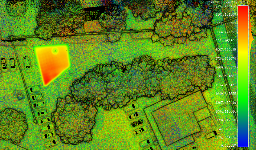
The number of laser points collected per unit area, usually expressed in points per square meter (pts/m²).
High point cloud density can provide more detailed terrain and object features, but it also increases the complexity of data processing. In terrain modeling or forest resource surveys, high point cloud density can generate more detailed digital elevation models (DEMs).

About Tersus GNSS Inc.
Tersus GNSS is a leading Global Navigation Satellite System (GNSS) solution provider. Our offerings and services aim to make centimeter-precision positioning affordable for large-scale deployment.
Founded in 2014, we have been pioneers in design and development GNSS RTK products to better cater to the industry’s needs. Our portfolios cover GNSS RTK & PPK OEM boards, David GNSS Receiver, Oscar GNSS Receiver, MatrixRTK [GNSS CORS Systems] and inertial navigation systems.
Designed for ease of use, our solutions support multi-GNSS and provide flexible interfaces for a variety of applications, such as UAVs, surveying, mapping, precision agriculture, lane-level navigation, construction engineering, and deformation monitoring.
Sales inquiry: sales@tersus-gnss.com
Technical support: support@tersus-gnss.com
