Analysis of Errors in GNSS Positioning
Wenfeng Zhang, Tersus GNSS 6 SEP. 2024
Analysis of Errors in GNSS Positioning
GNSS (Global Navigation Satellite System) is a navigation and positioning system based on satellite positioning technology. GNSS has been the indispensable tool in more and more industries, such as aerospace, construction, transport, city planning, agriculture, etc. However, there are lots of errors result from satellites, propagation path, the GNSS receiver when we performing the GNSS positioning. These errors inevitably affect the measurement. This article introduces these errors and how to reduce and eliminate them.
Based on the source of errors, we can categorize errors into four parts: the error related to GNSS satellites, error related to signal propagation, the error related to the receiver, the other errors.
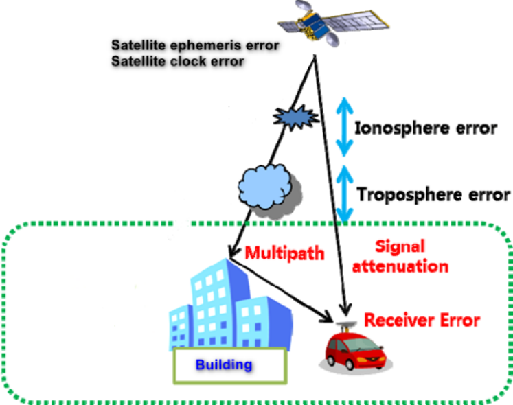
Errors related to GNSS satellites
Satellite ephemeris errors
Due to the complex influences of various perturbations during satellite motion and the difficulty of reliably measuring these forces through ground monitoring stations, there are errors between the predicted satellite positions based on ephemeris data and the actual positions.
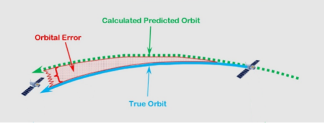
Satellite clock errors
Although GPS satellites are equipped with high-precision atomic clocks (rubidium and cesium clocks), there are still deviations or drifts from the ideal GPS time.
How to reduce the impact of these errors?
a) IGS precise ephemeris provide high-precision satellite orbit parameters and clock error even though the IGS precis ephemeris issued once every two weeks
b) By using the synchronized observation of the same satellite from two or more stations and calculating the difference, the impact of ephemeris error and clock error can be mitigated.
Errors related to propagation path
The ionospheric refraction errors
When the satellite signal pass ionosphere, the speed and direction of signal will be affected by a mass of electron and ion.
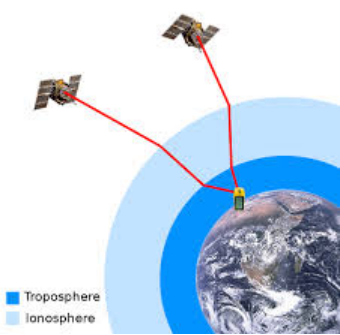
The tropospheric refraction errors
When the satellite signal pass troposphere, the speed and direction of signal will be affected by variation of atmospheric pressure temperature and humidity.
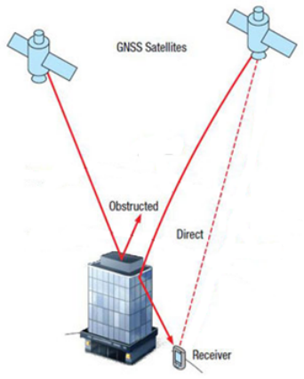
The multiple-path error
If the satellite signal is reflected by nearby objects like buildings and then enters the GNSS antenna, it will interfere with the signal directly enters the GNSS antenna, severely affecting measuring accuracy.
How to reduce the impact of these errors?
Here are some methods to reduce ionospheric refraction errors.
a) Utilize two or more observation stations when they are within short distances (<20km).
b) Employ dual-frequency or multiple-frequency GNSS receiver.
c) Utilize the ionospheric model provided by navigation message or other sources.
Here are some methods to reduce tropospheric refraction errors.
a) Common tropospheric refraction correction models, such as the Hopfield model and the Saastamoinen model, can reduce more than 90% of refraction effects.
b) When the atmosphere is table, utilize two or more observation stations when they are within short distances (<20km).
c) Use the expensive device to directly measure the effect of water vapor on satellite signal.
Here are some methods to reduce the multiple-path error.
a) The observation should keep away from the strong reflective surface such as large bodies of water, building facades, mountains.
b) Choose the chocking-ring antenna or other well-shield antenna.
c) Extend the observation time appropriately.
Errors related to the receiver
The receiver clock error
The receiver clock error stems from inaccuracies in the internal clock of the GNSS receiver, which is less precise than the atomic clocks used in GNSS satellites.
The receiver placement error
This error occurs due to improper positioning of the GNSS receiver antenna, which can lead to significant measurement error.
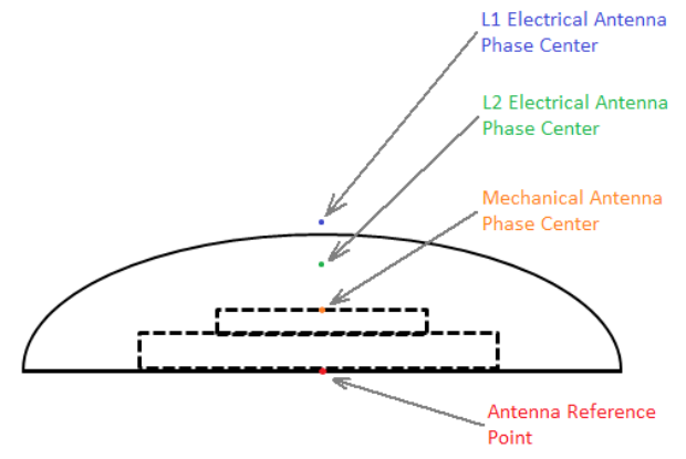
The phase center error
The phase center error arises because the phase center of the GNSS center of GNSS antenna (the point where the signal is received) does not coincide with the geometric center of the antenna.
How to reduce the impact of these errors?
Here are some methods to reduce the receiver clock error
a) Utilizing GNSS receivers with high-precision clocks can significantly reduce clock errors.
b) Applying differential correction techniques, where corrections from a base station with a known position are used, can help mitigate clock errors.
c) Synchronizing the receiver clock with an external accurate time source can minimize these errors.
Here are some methods to reduce the receiver placement error
a) Whenever possible, mount the GNSS antenna on a forced centering device to ensure precise and consistent placement.
b) Regularly calibrate the GNSS antenna to account for any physical displacements or biases.
Here are some methods to reduce the phase center error
a) If the antenna has been tested by IGS or NGS labs, use the antenna PCO (Phase Center Offset) parameters provided on their websites to compensate for this error.
b) Ensuring that the antenna is consistently oriented in the same direction during measurements can help maintain a stable phase center.
c) Using high-quality GNSS antennas with well-defined phase center characteristics, such as choke-ring antenna, can reduce phase center errors.
About Tersus GNSS Inc.
Tersus GNSS is a leading Global Navigation Satellite System (GNSS) solution provider. Our offerings and services aim to make centimeter-precision positioning affordable for large-scale deployment.
Founded in 2014, we have been pioneers in design and development GNSS RTK products to better cater to the industry’s needs. Our portfolios cover GNSS RTK & PPK OEM boards, David GNSS Receiver, Oscar GNSS Receiver, MatrixRTK [GNSS CORS Systems] and inertial navigation systems.
Designed for ease of use, our solutions support multi-GNSS and provide flexible interfaces for a variety of applications, such as UAVs, surveying, mapping, precision agriculture, lane-level navigation, construction engineering, and deformation monitoring.
Sales inquiry: sales@tersus-gnss.com
Technical support: support@tersus-gnss.com
