Differences between RTK and PPP
Chenge Zang, Tersus GNSS 21 OCT. 2024
Differences between RTK and PPP
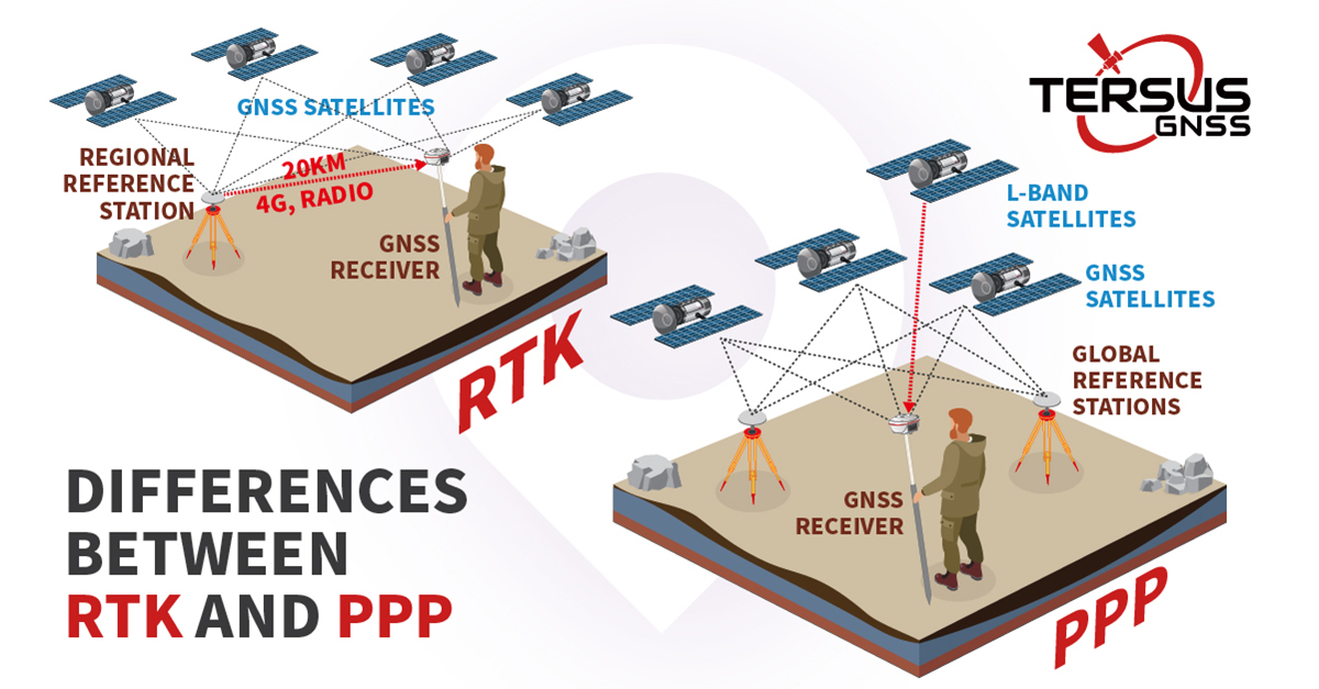
RTK (Real-Time Kinematic) and PPP (Precise Point Positioning) are two well-known technologies in GNSS positioning that have been developed over decades. In RTK positioning, the rover station obtains the simultaneous observation data from the base station or CORS for double-difference ambiguity fixing, so as to quickly achieve high-precision real-time positioning. However, RTK positioning technology is limited by the communication link for correction data transmission and the distance between the rover and the base station (or the coverage of the CORS network), resulting in a lack of operational coverage. PPP positioning can directly achieve high-precision positioning by using a single GNSS device, breaking through the limitation of the operating range, and greatly increasing the flexibility of the device’s use, while it takes a certain amount of time to converge to obtain the results of PPPAR (Precise Point Positioning with Ambiguity Resolution).
With the rapid development and iteration of high-precision real-time positioning technology, both RTK and PPP have been applied in many fields, such as autonomous driving, intelligent agriculture, UAV, marine positioning and other emerging industries. According to the characteristics of RTK and PPP, the appropriate positioning technology should be selected. The reason for the difference between RTK and PPP lies in the difference in their positioning methods.

The essence of GNSS high-precision positioning is a process of eliminating errors in GNSS positioning. In terms of the sources of GNSS positioning errors, the single-point positioning of GNSS device includes satellite-side orbital errors, clock errors, satellite bias, the effects of the ionosphere and troposphere on the propagation path and receiver-side errors. In RTK positioning technology, the observation data of the base station or the virtual base station calculated by CORS service is transmitted to the rover station through the radio, network and other communication links, and then centimetre-level positioning is realized by eliminating the satellite-side error and propagation path delay through the double-difference calculation of the observation data from the base station and the rover station. The idea of eliminating the error in PPP positioning technology is completely different. For satellite-side orbit error, clock error, bias and other errors, the GNSS device directly receives ORB, CLK and other data broadcast from the satellite to achieve the elimination of these errors, and then through the UPD (Uncalibrated Phase Delay) phase fractional deviation estimation and other methods to achieve the PPP ambiguity resolution to get high-precision results ultimately.
From the two methods of the two different positioning technologies above, it is not difficult to find that in RTK positioning technology, the correction data transmission communication link is crucial. If the rover station in the vicinity of the base station and communication link is smooth, the RTK positioning effect is best. PPP positioning technology directly receives the elimination of positioning error correction data from the satellite side, so it no longer communicates with the base station and does not need to focus on the distance from the base station. The two are a bit like the daily use of smartphones through the ground base station to obtain 5G network signals and directly through Starlink to achieve a connection to the Internet.
As a leading high-precision satellite navigation professional enterprise, Tersus has recently launched TAP, a satellite-based rapid convergence service under PPP positioning technology, which also means that Tersus GNSS boards or receivers can achieve both RTK positioning technology and meet the requirements of PPP positioning technology, to realize the high-precision positioning requirements in different scenarios.
About Tersus GNSS Inc.
Tersus GNSS is a leading Global Navigation Satellite System (GNSS) solution provider. Our offerings and services aim to make centimeter-precision positioning affordable for large-scale deployment.
Founded in 2014, we have been pioneers in design and development GNSS RTK products to better cater to the industry’s needs. Our portfolios cover GNSS RTK & PPK OEM boards, David GNSS Receiver, Oscar GNSS Receiver, MatrixRTK [GNSS CORS Systems] and inertial navigation systems.
Designed for ease of use, our solutions support multi-GNSS and provide flexible interfaces for a variety of applications, such as UAVs, surveying, mapping, precision agriculture, lane-level navigation, construction engineering, and deformation monitoring.
Sales inquiry: sales@tersus-gnss.com
Technical support: support@tersus-gnss.com
